
|
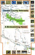
Self Guided Touring Routes
Professional Guided Bird Tours are locally available for bird viewing on private and public lands.
This page is still under construction as we gather and check mileage for the different routes, and write directions. Please be patient.
*Important Warning
Remember as you drive the self-guided auto routes that most land on either side of the road is
private property. Property owners permission is required to enter lands.
*Important Warning
Most roads in Garden County are dirt. County Roads are well maintained, but incremental
weather can have immediate adverse affects on the roads. Many roads are a sand base.
*Use caution when stopping on road edges.
Oshkosh:
Rd 183 Burrowing Owls nesting grounds
Rd 52 5 miles south of Oshkosh. East of Hwy 26. 5 miles each - dead ends at private property fenceline. Turn around near mailbox. This route has the river, brush and trees to the north, grassland and prairie to the south.
Rd 175 6 miles south of Oshkosh. West of Hwy 26. Curving road travels up through canyon. Other animal species that may be spotted on this route are Long-haired Jennets, Lamas, Buffalo, Elk, Deer, Red Sheep and purebred Trans-Caspian Urial Sheep.
Lewellen:
Rd 199ALewellen Bridge south of Lewellen
Hwy Rd 207 - Rd 48 - Rd 199A Loop
Rd 44 West of 199A and East of 199A to US Hwy 26
Lewellen Bridge: Rd 199A .2 miles south of Lewellen. Plan on spending a little extra time to stop, park, and walk across this this Historic Truss and Pony bridge. Completed in 1927, it consists of seven 100' riveted Pratt pony trusses, supported by 50-foot-long, Bethlehem H-pile piers, encased in concrete. An important crossing of the Platte River, it is oneof the last two intact multiple-span state aid truss bridges.
Many locals call this "Fisherman's Bridge", and you might find several anglers with their lines hanging over the bridge into the water.
It is very unusual to not spot one to several species of birds and waterfowl while on the one-lane bridge and the tree shaded road to the north and south.
Lisco:
Lisco Bridge: Rd 151 - .4 mile south of Lisco. You might want to schedule a little extra time to stop here, park, and walk across this Historic Truss and Pony bridge. Completed in 1928, it consists of eight 80' spans. It, like the Lewellen Bridge, is distinguished as an important crossing of the Platte River and one of the last two intact multiple-span state aid truss bridges.
Looking down from the bridge, you might spot schools of fish, muskrats, beaver, listen to the nearby turkeys, and catch glimpses of birds in the trees, brush and grasses on the islands in the river the bridge passes over.
North Platte River Road:(between Oshkosh and Lisco)
Rd 54 From Oshkosh - take Hwy 27 south for 1.6 miles. West on Rd. 54. for 18 miles, turning north on Rd. 151 into Lisco.
The road follows the old Oregon, California, and Mormon Trails along the river. The grave of John Hollman who was buried in 1852 is on the north approximately 1 mile from Hwy 27. Prairie, grass, fields to south of road. River, trees, brush to north. Road follows river to Lisco. Turn north at Rd 151 and cross the bridge into Lisco. (app. 20 miles)
Crescent Lake Routes:
From Lisco:
From Oshkosh:
From Hwy 26/Hwy 27 intersection, proceed north on West 2nd through town.
The road name changes to Rd 179 as you leave city limits.
Pavement ends 2.9 miles north of town.
Continue north on 179 until you come to a T at Rd 82 (12.2 miles).
Follow arrows on sign, turning east (right) for .7m.
Turn north at sign at the Y in road, and follow Rd 181 6.7m to the Crescent Lake National Wildlife refuge entrance gate. (road narrows for a half mile section of single lane pavement on road 181 widens out to two lane dirt again for about 5 miles, then again changes to a narrow two lane pavement to the refuge gate. Roads within the Refuge are narrow, single lane, hole pocked pavement, and dirt roads.)
Refuge Headquarters is 3.9 miles past the gate.
(19.4 miles from town to Refuge Gate, 23 miles from Hwy 26 to Refuge Headquarters)
From Lewellen:
Crescent Lake National Wildlife Refuge
Clear Creek Wildlife Management Area /
Lake McConaughy Recreation Area:
Rd 44 East of US Hwy 26
|


![]()
 Copyright © 2009-2012